Archive of original article
This is an archive of the original article as it was published on www.geomatics.org.uk about mapping the refugee camps of the Gaza Strip. Please note that this article was originally written in 2002 and any information within might not be accurate anymore.
The creation of the new Palestinian Authority and the implementation of the Oslo Accords in 1994 helped open the door to environmental donor project investment in the teeming Palestinian refugee camps of the Gaza Strip in 1994.
James Kavanagh, a graduate of Dublin Institute of Technology and the University of East London was seconded to UNRWA (United Nation Relief & Works Agency for Palestinian Refugees) along with a group of 5 Irish professionals.
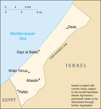
The planned environmental projects called for urgent and accurate mapping of the sprawling refugee camps which contain up to 1 million people squeezed into a 10km by 50km rectangle of the eastern Mediterranean coastline.
Background
The refugee camps were set up in the late 1940’s to accommodate the fleeing indigenous Palestinian population who had been forcibly removed from their homes by the creation of the state of Israel. The camps were never envisaged to provide long term accommodation and so, were bereft of even the most basic amenities such as sewage systems and running water. Like their counterparts in Lebanon the camps became the battleground of the Palestinian uprising or ‘intifada’. It was decided by all parties at the peace talks of the 1990’s that the conditions in the camps were a major contributor to Palestinian resentment and a fertile recruiting ground for militant groups. The Peace Implementation Programme was set up in 1994 with a view to changing the horrendous camp living conditions, and the mapping of the camps at scales of 1: 500, 1:1000 & 1:2500 became one of the building blocks of the peace process.
The Mapping of the Gaza Strip Camps
James started as Chief Surveyor with UNRWA in 1994, flying from the cool summer of Dublin to the humid, scorching heat of the Gaza Strip. The job remit required not only the production of digital map information for all UN agencies such as UNEP & UNHCR but also involved the training of a number of local Palestinian Surveyors in using modern Survey equipment and technology. From the central UN field office in Gaza we started our ground reconnaissance of the maps comparing the previously produced maps of the camps with existing ground conditions.
An Israeli aerial survey company had already flown the area and produced digital maps of most of the camps. It soon became apparent that they had not used ground control within the camps themselves (due to the danger) and that severe map errors (caused by rotation and poor scaling of the photographic images) were commonplace. This called for a bit of the surveyor’s art of improvisation.
Much of the mapping, benchmark and network control within the strip had been destroyed by the departing Israeli Defense Force: records of the remainder were spread around lots of individual surveyors. British Survey of Palestine (1930’s & 1940’s), Egyptian military, Israeli and even Ottoman Turk cadastral maps were uncovered and pieced together to form a basic network of existing horizontal and vertical control. Some benchmarks were even buried in graveyards, although water towers were the usual hiding places for control.
Each camp was seen as a separate project going from Jabalia in the north (the largest camps), Beach Camp (next to Gaza City), Bureij, Magazi and Nuseirat (the middle camps) down to Deir El Balah, Khan Yunis and Rafah on the Sinai desert border.
Ground control traverses were completed and survey software used to rectify the distorted mapping. Also, ground surveys of all alleys, open sewers, streets and adjoining building were completed and ‘grafted into’ the digital files.
By the end of each project the digital map of the camp was completed and ready for use by the design Engineers.
All the camps in the Gaza Strip were then tied together by a GPS network survey.
The skills needed for this job really brought home the need for the Geomatics Surveyor to be not only technologically proficient but also to be aware of the political and socio-economic effects of our work. Great diplomatic skill was needed on a daily basis, as the mapping of an area is significant in underlining its permanency, a fact unpalatable to a distressed population who still dream of returning to their pre-1947 homes in Palestine.
Also, we were required to complete cadastral work on behalf of the UN and Islamic Waqf and to pinpoint camp boundaries.
This project was one of the most incredible experiences of my life and shows how we as a profession can have a real impact on the lives of people in the developing world.
The increase in the use of GIS and GPS and their relatively low cost makes them incredibly useful in most situations where the UN is active. From disaster preparedness strategies to land mine mapping, the UN has recognized the worth of Geomatics technologies and are employing Geomatics professionals in increasingly large numbers throughout the world.
Useful Websites
- www.unep-wcmc.org | United Nations Environment Programme – World Conservation Monitoring Centre
- www.unhcr.org | United Nations High Commission for Refugees
- www.un.org | United Nations
- www.arij.org | Applied Research Institute – Jerusalem
Acknowledgement: Text and photos by James Kavanagh